Medieval Geographies
One of the abiding myths about the Middle Ages is that benighted folk of that period believed the earth to be flat and that one could literally sail off the edge of the world. In fact, any medieval people with even a rudimentary education—certainly even many without such an education—understood the earth to be a sphere. Indeed, by the later Middle Ages, following the study of the classical geographer Ptolemy and his Arabic commentator Alfraganus, medieval scholars estimated the circumference of the globe to be about 20,000 to 24,000 miles—not too far off from the precise modern calculation of 24,901 miles. Following, again, both classical and Arabic sources, they believed the sphere of the earth to occupy the center of the universe, surrounded by the spheres of the planets and of the fixed stars, which all revolved around it.
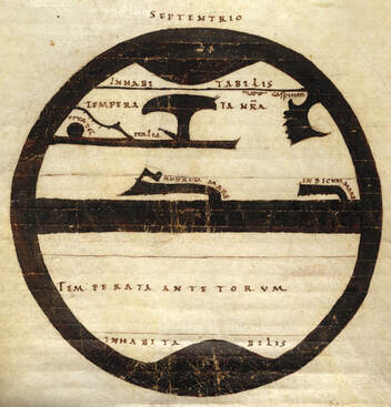
Eleventh-century "map" showing the five zones. The black represents the seas that surround and separate the two major landmasses; the Mediterranean Sea, the Black Sea, and the Red Sea define the basic shape of the known world. (British Library Harley ms 2772)
|
According to one of the more influential geographic concepts imported from Roman-Hellenistic Antiquity, and transmitted to the Middle Ages through the late Roman writer Macrobius (fifth century) and the early medieval encyclopedist Isidore of Seville (sixth century), the sphere of the earth was divided into five latitudinal zones. The most northerly and southerly zones, situated around the two poles, were uninhabitable because of their intense cold. The central, equatorial zone, was also inhospitable to life because of its excess heat. Between these uninhabitable zones stood two temperate zones, and it was there that the human population of the world dwelt. The world known to Europeans (roughly speaking, Asia, Africa, and Europe) was located in the more northerly temperate zone. The southern temperate zone was known as the Antipodes and its inhabitants as Antipodeans. Their existence was only speculation, however, generated probably by a passion
|
for geographical symmetry: medieval Europeans expected never to encounter Antipodeans because to do so would involve crossing the fiery equatorial zone. It was only later that the idea of how the Antipodeans got there in the first place would vex the medieval mind. If the Antipodeans were descendants of one of Noah's three sons, how were they able to come to the southern hemisphere? Had God simply placed them there? Were the Antipodeans even human?
A more pervasive, and perhaps somewhat more commonsensical geographical system developed in the early Middle Ages was to imagine the Eastern Hemisphere of the spherical earth as, functionally speaking, a disk. The great continents of Asia, Africa, and Europe occupied the bulk of this disk and were surrounded by the Ocean, which also covered the entirety of the opposite side of the globe (what we would now call the Western Hemisphere). This understanding of world geography was typically represented by what are known known as T-O maps. The "T-O" refers both to the Latin phrase terrarum orbis and to the characteristic shape of such maps, which usually appear
A more pervasive, and perhaps somewhat more commonsensical geographical system developed in the early Middle Ages was to imagine the Eastern Hemisphere of the spherical earth as, functionally speaking, a disk. The great continents of Asia, Africa, and Europe occupied the bulk of this disk and were surrounded by the Ocean, which also covered the entirety of the opposite side of the globe (what we would now call the Western Hemisphere). This understanding of world geography was typically represented by what are known known as T-O maps. The "T-O" refers both to the Latin phrase terrarum orbis and to the characteristic shape of such maps, which usually appear
|
as the letter "T" within a letter "O": the "T" represents the bodies of water (the Mediterranean, the Danube, and either the Nile or the Red Sea) separating the three continents, while the "O" corresponds to the circular shape of the inhabited world. The earliest T-O maps were mere diagrams, intended to convey conceptual rather than actual geographical information. Indeed, their tripartite division of the world could convey powerful hierarchies: the three "continents" of Asia, Europe, and Africa were said to have been populated by the three sons of Noah—Shem, Japheth, and Ham respectively. The shaming of Ham in Genesis 9 demoted his African descendants, while the failure of the Jewish descendants of Shem left the European Japhethic peoples as the natural heirs to spiritual (and political) power. The situation of Jerusalem at the center of the T-O maps was a detail certainly not overlooked by generations of actual and would-be Crusaders, for whom it represented the ultimate prize.
|
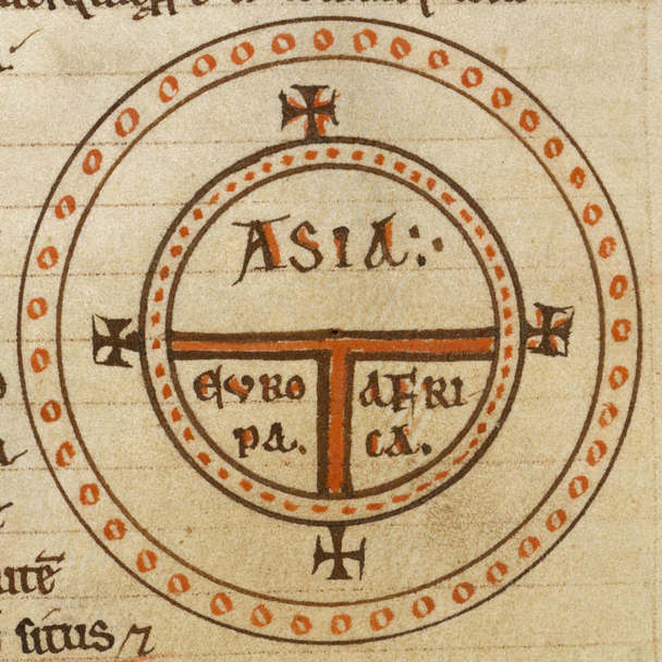
A classic "T-O" map, aligned with East at the top and showing the three landmasses of Asia, Africa, and Europe. (From a 12th-cent. manuscript of Isidore of Seville's Etymologies.
|
Over the centuries, as one map was copied from another, details accumulated, and the maps were expanded—and literally grew in size—to accommodate illustrations and further detail. This process culminated in the great mappae mundi of the high Middle Ages, detailed world maps the same general layout of the T-O diagrams: Asia and "the East" at
|
the top, the Pillars of Hercules at the bottom, the Mediterranean and other bodies of water dividing the three major landmasses. The Garden of Eden usually appears at the top, and the city of Jerusalem—where the Temple of Solomon stood and where Christ was crucified and resurrected—in the center. In general, the mappae mundi led the viewer through the central points of salvation history: a vertical scan from the top center to the middle brought one from the Garden of Eden, past Noah's Ark and the Tower of Babel, to Babylon and Jerusalem. Less central details on such maps included the exploits of Alexander the Great, the Crossing of the Red Sea, and the Egyptian pyramids (believed to be giant granaries). On some maps, such as the Hereford Mappa Mundi, details from pagan mythology such as the Golden Fleece were also incorporated into the historical program. Predictably such maps tended to be crowded with relatively accurate features in Europe and around the Mediterranean basin, where pilgrimage routes and the Crusades had brought considerable knowledge of the layout of the Holy Land, Egypt, and the Aegean. That said, even what are to us the most obvious kinds of geographical features—like the fact that Italy is shaped like a boot or that the Black Sea is connected to the Mediterranean by a narrow straight—are completely absent from the medieval mappae mundi. While modern maps aim to represent the world from something like a bird's-eye view, the medieval geographic ideal sought to represent the world as an ordered cosmos, a collection of diverse and sometimes wondrous features contained within a rational and ordered whole.
|
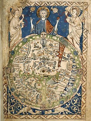
The Psalter World Map (England, 13th cent.), is a great exampla of a mappa mundi. The T-O paradigm is still discernible.
|
The Golden Fleece, in the Hereford Mappa Mundi (ca. 1300)
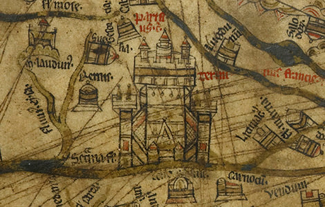
Paris in the Hereford Mappa Mundi is accurately situated on an island on the Seine. The Eiffel Tower is, alas, not pictured.
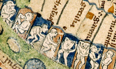
Monstrous races, crowded at the edge of Africa in the 13th-cent. English Psalter World Map
|
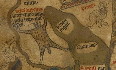
High medieval maps may have encapsulated ideas about the march of history and the proper "order" of the world, and so they also expressed some of the ways Europeans thought about the features and inhabitants of other parts of the world. Asia and Africa were often replete with fantastic gems and dangerous or outlandish creatures—not only elephants, camels, and crocodiles, but also dragons, basilisks, wyverns, griffins, and the Phoenix. Marco Polo's famous book Il Milione (The Travels of Marco Polo) provided some accurate information about China ("Cathay") but also greatly expanded the traditional inventory of the fabulous beasts and terrifying dangers to be encountered beyond the Mediterranean basin. Typically, the edges of the mappae mundi were dotted with illustrations of often strange exotic peoples: the Cynocephali (a dog-headed race), the Blemmyae (with no heads and faces in their chests), the Sciopods or Monopods (one-footed people), cave-dwelling Troglodytes, cyclopes, centaurs, satyrs, people with horns, etc.; Marco Polo added details about spice-growers, cannibals, and a secret cult of assassins.
Although these fabulous peoples derived from a wide range of classical, medieval, and Arabic sources, their appearance on medieval maps captured European fear of the unknown and fascination with the "Other": in contrast to the riches and wonders of Asia, or to the marvelous races of Africa and India, or to the fantastic beasts to be found at the edges of the world, Europe in general (and Latin Christendom in particular) implicitly stood as the bastion of domestication and civilization, and the European body stood as the presumed norm against which the bodies of "exotic" others were measured. Such representations doubtless influenced the way Europeans continued to think about non-Europeans as the sixteenth and seventeenth centuries brought the Age of "Discovery" and the beginnings of colonial exploitation. |
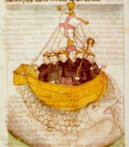
St Brendan and his intrepid monks landing on the "island" Jasconius.
Although no medieval people seriously believed that one could sail off the edge of the earth, sea travel was still thought to be inherently dangerous. (From a 12th-cent. English ms.)
|
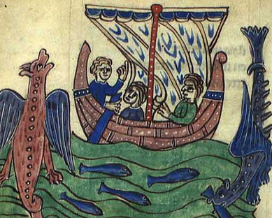
The medieval imagination was sometimes also directed to the areas "off the map," so to speak. The legendary voyages of the sixth-century St Brendan "the Navigator" were quite the vogue in the early twelfth century, extant in both Latin and French versions. Modeled on even older Irish tales of magical sea-travel (immrama), they recounted the sailor-saint's adventures with his small crew of fellow monks across the broad expanse of the Atlantic Ocean, where they land upon a series of marvelous islands, one of which turns out to be an enormous sea-monster called "Jasconius"! Less obviously fictionalized, some of the Icelandic sagas speak of Norse expeditions to Greenland (never pictured on European mappae mundi) and beyond; remains of an ill-fated Norse settlement in what is now Labrador have been excavated. Even when no ships went there, the medieval mind sometimes pondered the expanse of the western hemisphere. The Travels of Sir John Mandeville speculates that a traveler embarking due east from India would sail the enormous distances of empty sea only to return, eventually, to India again. Dante Alighieri, drawing from older notions of the Antipodes, places his Mountain of Purgatory on an island in the middle of this eastern (or western) Ocean, at a point directly opposite Jerusalem, the center of the known world; he tells as well of Ulysses' hubristic failure in attempting to sail there. All such speculations—fictional and otherwise—were of course part of the mental furniture that occupied the mind of Columbus and others who sought to find an overseas route to India.
With the increased use of astrolabes (after the eleventh century), compasses (in the fourteenth century), and portolan charts (in the fifteenth century), there was a blossoming of European awareness of geographic precision, and its desire for greater cartographical realism. Fifteenth-century |
Portuguese expeditions of the African coast, culminating in the rounding of the Cape of Good Hope in 1488, began the long process of accurately mapping the world. But we should note in closing that the development of geographical knowledge was never innocent of economic, political, and religious concerns. The great age of the mappae mundi corresponded more or less with the Crusades; Marco Polo followed trade routes to China; Prince Henry the Navigator sought to open up sub-Saharan markets, but he also aimed at establishing a political alliance with the legendary Prester John and the St Thomas Christians of India; and Christopher Columbus, working off a hint from Mandeville's Travels, hoped that contact with the East Indies would bring not only wealth but a vital alliance with potentates in India or China to aid in a global war against Islam. In the contours of the medieval mind can be found, for good or (probably mostly) for ill, the makings of the modern world.
Further Reading
- Bede, On the Nature of Things and On Times, trans. Calvin B. Kendall and Faith Wallis (Liverpool University Press, 2010)
- Mary B. Campbell, The Witness and the Other World: Exotic European Travel Writing, 400-1600 (Cornell University Press, 1991)
- Ibn Fadlan, Ibn Fadlan and the Land of Darkness: Arab Travellers in the Far North, trans. Paul Lunde (Penguin Classics, 2012)
- Valerie I. J. Flint, "Monsters and the Antipodes in the Middle Ages and the Enlightenment," Viator 15 (1984): 65-80
- Geraldine Heng, “The Invention of Race in the European Middle Ages II: Locations of Medieval Race.” Literature Compass 8.5 (2011): 332–50
- Isidore of Seville, The Etymologies of Isidore of Seville, trans. Stephen A. Barney et al. (Cambridge University Press, 2010)
- Naomi Kline, Maps of Medieval Thought: The Hereford Paradigm (Boydell Press, 2001)
- Macrobius, Commentary on the Dream of Scipio, trans. William Harris Stahl (Columbia University Press, 1966)
- The Old English History of the World: An Anglo-Saxon Rewriting of Orosius, trans. Malcolm Godden (Dumbarton Oaks Medieval Library, 2016
- Natalia Petrovskaia, Medieval Welsh Perceptions of the Orient (Brepols, 2015)
- Marco Polo, The Travels of Marco Polo, trans. Ronald Latham (Penguin Classics, 1958)
- The Travels of Sir John Mandeville, trans. C. W. R. D. Mosely (Penguin Classics, 1983)
- The Vinland Sagas, trans. Keneva Kunz (Penguin Classics, 2008)
- The Voyage of St Brendan, trans. John J. O'Meara (Colin Smythe, 1981)
